|
|
|
|
|
|
Prague Map
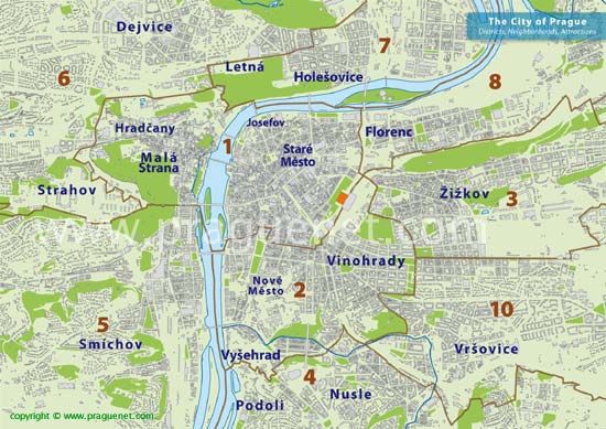
The Prague map (Praha map for the initiated) gives a quick overview of the exciting Czech city and Prague districts and neighborhoods as well as essential Prague City Map information for tourists. Prague is big but getting around is easy, thanks to its excellent public transportation. A glance at the map shows that the city is divided into 10 districts (Prague 1, Prague 2, etc.) which refer to each of the Prague neighborhoods; in many cases locals use the neighborhood names (Stare Mesto, Mala Strana, Vinohrady, etc) more frequently than the district numbers . Although most first time visitors want to stay in Old Town, many of the neighboring districts have sections that are within easy walking distance of the major tourist attractions and offer better value for the price. Look at the Prague map to see where! Here's a quick overview of the Prague districts and Prague neighborhoods.
|
Prague 1
|
Stare Mesto (Old Town). The geographical center of Prague and the home of its best known tourist attractions; many buildings in Prague 1 date back to the 13th century. Charles Bridge (Karlov Most), Old Town Square (Stare Namesti), Wenceslas Square (Waclavske Namesti), the Jewish Quarter (Josefov) and many other popular tourist destinations can be found here. The area is also popular among locals for its wide variety of trendy boutiques, restaurants, trendy nightlife and modern shopping centers. Nonetheless, everything from accommodation to beer tends to cost quite a bit more in Prague 1 than it does elsewhere in the city. Book a Hotel in Old Town » |
| Mala Strana. The Vltava River divides Prague in half and because of this, the Old Town is split into two distinct neighborhoods. The Mala Strana side (lesser side) is located just across the Charles Bridge from Old Town, at the bottom of the hill that leads up to Prague Castle. It is known for the many embassies that are located here. Quiet and very upscale, it is the most exclusive neighborhood in Prague. Many of Prague's finest restaurants can be found here, as well as elegant cafes and tourist shops. Situated alongside the river, Kampa Park is a nice place to enjoy the beautiful views of Prague. Book a Hotel in Prague 1 » | |
|
Prague 2 |
Vinohrady - Located at the top of the hill just beyond the far end of Wenceslas Square, Vinohrady is named for the vineyards that were found here during the 19th century. Today it is one of the most desirable Prague neighborhoods; it's most popular among young professionals, international residents, and other well to do residents who like its chic cafes, upscale shopping centers and restaurants. Much of the neighborhood is within easy walking distance of Wenceslas Square and excellent bus and Metro service is available throughout. A good location for escaping the tourist crowds, yet still close to the center. Hlavni Nadrazi (Prague's Main Train Station) is located here, near the point where Prague 1, 2 and 3 come together. Book a Hotel in Vinohrady » |
| Vysehrad - This part of Prague 2 is located on a hill between the Vltava river and the Nusle neighborhood of Prague 4. It is interesting for the Vysehrad castle (Prague's other castle), the neighboring church and cemetery, as well as its views over the city. The portion alongside the Vltava river offers excellent views and easy access to the Smichov area of Prague 5, directly across the river. While Vysehrad doesn't provide as easy access to the city center as Vinohrady, most parts are only ten or fifteen minutes away by tram or metro and it offers the advantage of being more affordable and providing a more authentic glimpse of Czech lifestyle than Vinohrady. Book a Hotel in Prague 2 » | |
|
Prague 3 |
Zizkov - A favored Prague neighborhood among the students and young expats, Zizkov is traditionally one of the less affluent neighborhoods. Yet this district encompasses a trendier side. The areas located adjacent to Old Town and Vinohrady are replete with the pubs, restaurants and the famous architectural stylings that those areas are known for. Farther out in Zizkov you won't have to look to hard to find dingy and depressing Communist era housing. But tourists who decide to venture out into the Zizkov neighborhood will be rewarded with the magnificent views offered by the Prague TV tower. Book a Hotel in Prague 3 » |
|
Prague 4 |
A large, primarily working class Prague district, Prague 4 isn't highly desired by tourists or recent arrivals. Nonetheless some areas can be quite attractive. Podoli, is nice for its location alongside the river, its traditional Czech restaurants and pubs and a generally unspoiled sampling of traditional Czech lifestyle. The Nusle neighborhood, around Namesti Bratri Synkou square also offers affordable accommodation in a traditional Prague neighborhood setting. From these areas the city center is easily accessible by tram. Elsewhere in Prague 4 the landscape is dotted with large Soviet era residential towers (panelaks), but neighborhoods on the outskirts often have a rural setting. Access to the center is good when close to a metro line, but for the most part long commutes can be expected. Book a Hotel in Prague 4 » |
|
Prague 5 |
One of the largest Prague districts, the Smichov neighborhood, alongside the river and around the Metro station Andel, is an upscale neighborhood with newly renovated buildings, hotels and the large Novy Smichov shopping center. Trendy restaurants and nightlife abound. Farther out is more residential with houses, recent housing developments and the French school of Prague. Barrandov is the location of Prague's movie studios. Book a Hotel in Prague 5 » |
|
Prague 6 |
Known for its many embassies and numerous houses and villas as well as being the district that is nearest to Prague airport, Prague 6 is the location of some of Prague's most exclusive neighborhoods. The American School is located here along with the German and Japanese international schools and the Canadian Medical Center.The area around Dejvice provides easy access to the city center and abounds with restaurants and pubs. Book a Hotel in Prague 6 » |
|
Prague 7 |
Letna - Just across the river from Old Town, Letna is a quiet residential area popular among students, as well as those who want to be close to the center for a reasonable price. It is best known for Letna Park (Letenské sady), the biggest park in the center of Prague. Its superb beer garden offers unequalled views of the center of Prague and its winding paths are excellent for roller skaters and walkers. This neighborhood offers many charming pubs and restaurants as well as Prague's futbol (soccer) stadium. Good public transportation by tram and metro make Letna a more affordable alternative than Vinohrady, but still with easy access to the center. |
| Holesovice - Adjacent to Letna and just a bit farther from the City Center this Prague neighborhood is home to many office and industrial buildings as well as affordable housing. Prague's second international train station, Holesovice Nadrazi is located here. Farther out in Prague 7 is the even more affordable Troja district, where the Prague Zoo can be found. Book a Hotel in Prague 7 » | |
|
Prague 8 |
Florenc - For the most part this is one of the outlying Prague districts, but the area around Metro Florenc, where the central bus station and the monolithic Hilton hotel are located, is just a ten minute walk from the Old Town. The area around Karlin is near the river and close to a Metro line that runs to Prague 1. But the greater part of the district is not easily accessible from the center. Book a Hotel in Prague 8 » |
|
Prague 9 |
Cerny Most - Located just beyond Prague 3, this large outlying area is best known for its numerous Communist era public housing developments (panelaks) as well as its large shopping center. Commercial and industrial buildings alongside very affordable accommodation characterize this neighborhood; but it can take more than 20 minutes to reach the center by public transportation. |
| Letnany - Formerly home to the Avia aircraft factory, the district is now the site of upscale homes and the gigantic "Letnany Centrum" shopping center. A bit far out from the Center, which is accessible by Metro and bus. Book a Hotel in Prague 9 » | |
|
Prague 10 |
Vrsovice - A calm residential area just beyond Vinohrady. Young professionals, students, and families enjoy this Prague neighborhood for its authentic Czech shops, restaurants and pubs (plus a few modern shopping centers close by). This area is less influenced by the tourism and the breakneck pace of progress that characterize more central locations. Not within walking distance of the center, but still easily accessible with public transportation. Book a Hotel in Prague 10 » |
| Visiting Paris? Check out the Paris Map | |
WEBMASTERS: This page is copyrighted. You may link to this page from your website. However, any duplication, all or in part, is prohibited. Violators will be prosecuted under the terms of the DMCA (Digital Millenium Copyright Act)
|
|